The structural analysis software RFEM 6 is the basis of a modular software system. The main program RFEM 6 is used to define structures, materials, and loads of planar and spatial structural systems consisting of plates, walls, shells, and members. The program also allows you to create combined structures as well as to model solid and contact elements.
RSTAB 9 is a powerful analysis and design software for 3D beam, frame, or truss structure calculations, reflecting the current state of the art and helping structural engineers meet requirements in modern civil engineering.
Do you often spend too long calculating cross-sections? Dlubal Software and the RSECTION stand-alone program facilitate your work by determining section properties of various cross-sections and performing a subsequent stress analysis.
Do you always know where the wind is blowing from? From the direction of innovation, of course! With RWIND 2, you have a program at your side that uses a digital wind tunnel for the numerical simulation of wind flows. The program simulates these flows around any building geometry and determines the wind loads on the surfaces.
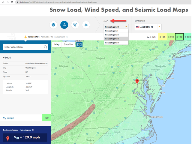
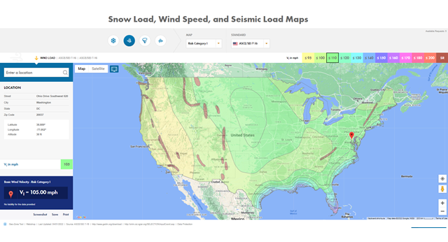
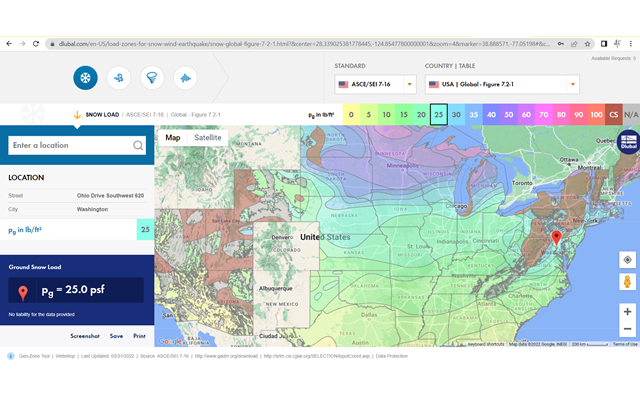
Are you looking for an overview of snow load zones, wind zones, and seismic zones? Then you are in the right place. Use the Geo-Zone Tool to determine quickly and efficiently snow loads, wind speeds, and seismic data according to ASCE 7‑16 and other international standards.
Would you like to try out the capabilities of the Dlubal Software programs? You have the opportunity to do so! The free 90-day full version allows you to thoroughly test all our programs.
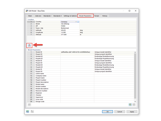
If the location-specific data are entered correctly in the model parameters or carried out using the search function on our website, the load information about the location is searched for automatically using the geo-data.
Thus, the load parameters for wind, snow, and earthquakes are transferred via our online service titled "Snow Load, Wind Speed, and Seismic Load Maps".
With our load wizard, you can automatically access these data without having to manually redefine the specifications for the location altitude, wind load zone, snow load zone, or seismic zone.
Various international standards or codes specify additional secondary values for the description of the load value specific for a location.
For example, the wind load description of the United States according to the code ASCE/SEI 7‑16 specifies various wind speeds for a location, depending on the defined risk category.
The Geo-Zone Tool always uses all location-specific parameters available from the load standard. In addition to the actual primary load value, further parameter maps are carried out in the background. These maps can be selected and displayed in the "Map" list box.
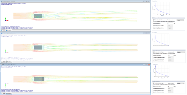
The SST k-omega model is used for the k-ω turbulence model.
In RWIND Simulation, the turbulence model is organized in the "Parameters of Simulation" menu under the "Turbulence" tab.
The RFEM or RSTAB interface menu organizes the turbulence model for the automatic calculation of wind loads in the background in the "Simulate and Generate Wind Loads" dialog box under the "Wind Load" tab. In this case, the "Use uniform turbulence at the inlet" function in the Turbulence Properties section creates a constant turbulence specification over the height of the wind tunnel. By deactivating this function, you can specify the turbulence variable over the height. In addition to the location-specific parameter of the wind speed profile, the turbulence property dependent on the terrain roughness over the height is also defined automatically. As an alternative, you can define the turbulence property manually in the form of a table entry using the "User-Defined Turbulence" function.